News Archive
-
GRUMETS are joining the 2015 edition of the annual assembly of EGU with several contributions, between them the direction and co-direction of 6 sessions of work. The assembly takes place in Vienna between April 12th and 17th. Here are the details of the participation.
-
-
13-04-2015
-
The Dictionary of Remote Sensing, updated and available online
-
The terminological Dictionary of Remote Sensing, written by Xavier Pons, Professor of Geographyin the UAB and Director of the research group Grumets from the CREAF and the UAB, and the researcher Anna Arcalís, and published in paper in late 2012 by the Institute of Cartography of Catalonia and Catalan Encyclopedia has been updated and published on the Internet so that you can see it online at http://www.termcat.cat/ca/Diccionaris_En_Linia/197.
The update has led to the revision of terms, particularly of platforms and sensors placed in operation since the publication of the dictionary, both in relation to the features and the dates of release or completion of service, as well as the incorporation of some new terms that have become sufficiently established for the addition to the 3500 entries that had this extensive work, unique in its field for the completeness and update.
Another novelty is that in the same Internet search environment it is possible to search the terms simultaneously in all the dictionaries of related themes also made with the advice of TERMCAT, specifically in that of Cartography (of the Professors Rabella, Panareda and Ramazzini from the UB), Geographic Information Systems (of the Professor Nunes from the UAB) and Photogrammetry (of Professor Fra from Unex).
The consultation allows for the translation into English and Spanish and it's also possible to search the terms in these languages, plus French in the case of Cartography.
For example, if we search for Landsat, we will get, in the dictionary results on Remote Sensing, the release date including the recent Landsat-8 (which was monitored and spread from the UAB campus) and the news of its OLI and TIRS new sensors, which can also be searched to find its innovative features.
17-03-2015
-
Grumets participate in a study on the 13 major challenges of climate change in the Mediterranean
-
Gerard Moré and Xavier Pons have contributed to a multidisciplinary article published in Global Ecology and Biogeography which analyzes the 13 major scientific challenges to withstand climate change in the Mediterranean. The article has had quite impact to various media. You can download the article here or read a summary here.
11-03-2015
-
Grumets is editing the journal GeoFocus since September
-
The assembly of the Group of Geographic Information Technologies of the Association of Spanish Geographers confirmed on June the transfer of the editing of the journal GeoFocus to the Grumets for the next 3 years. The journal was currently edited by the Department of Geography of the Autonomous University of Madrid.
GeoFocus journal (ISSN:1578-5157) is a scientific and technical journal with an international vocation specializing in geographic information science and its various applications. Continuously published in electronic form since 2001 and is open to contributions from the international scientific community, being a reference publication in the field of development and application of this technology. Since its origins is an entirely open access journal with no publication cost for authors and with full and free content download. Its main languages are Spanish, Portuguese and English and now will be edited two issues per year.
-
-
The journal is indexed and summarized in a large number of databases, directories, portals and scientific national and international repositories. Through the portal GeoFocus (https://www.geofocus.org/) the full text of the journal can be accessed in open mode in pdf format. GeoFocus is sponsored by the Group of Geographic Information Technologies of the Association of Spanish Geographers and receives institutional and technical support from RedIris (Spanish Network of R & D supported by the Government of Spain) .
03-03-2015
-
The next OGC Technical Committee and an Interoperability Day will be organized by Grumets in Barcelona
-
The next Technical Commitee of the Open Geospatial Consortium (OGC), scheduled for March, will take place in Barcelona and will be organized by Grumets. From 9 to 13 March, the members of the OGC will keep their internal meetings at the Casa de la Convalescència, at a meeting sponsored jointly with the Institut Cartogràfic i Geològic de Catalunya (ICGC) and with the support of ILAF, the Iberian and Latinamerican Forum of the OGC. The Technical Committee (TC) is one of the 4 attended international annual meetings that enable the Open Geospatial Consortium (OGC) to stimulate the ongoing work on the development of standards. The details of the next call can be viewed here.
The Forum itself and the Associació Catalana de Tecnologies de la Informació Geoespacial (ACTIG) will organize an Interoperability Day on Friday 13 March, devoted to discussions about OGC standards in national and regional levels, which will take place in the Institut Cartogràfic i Geològic de Catalunya (ICGC). The themes to be discussed are the JSON and GeoJSON formats as OGC standards, the TJS table fusion, the Geopackage format applied in La Rioja and the OGC standards and the meteorology. Here you will find the detailed agenda: http://goo.gl/SJtFRl and here you can register to come: http://goo.gl/forms/mcrPtSB7Uo.
-
-
23-02-2015
- Grumets coordinates an Observation Network of Networks
-
The European project coordinated by Grumets ConnectinGEO has started this February. The project will deal with the coordination of the Earth observation networks with communities of science and technology, industry sector, GEOSS, and Copernicus. The objective is to create a European network of networks of observations (ENEON), including observations from satellites, transported and in-situ, as well as the establishment of a prioritized list of critical deficiencies within the European Union in the framework of Earth observations and models to translate observations into applied knowledge. The prioritized list include research activities necessary to address these gaps. It will address a range of issues, from climate, natural resources and raw materials, to emerging Sustainable Development Goals (SDG) proposed by the UN, hoping to increase the coherence of observation networks in Europe and increase the use of Earth observations for assessments and forecasts and planning for future observing systems. The kick-off meeting of the project will take place on next 18th and 19th of February in Barcelona.

6-02-2015
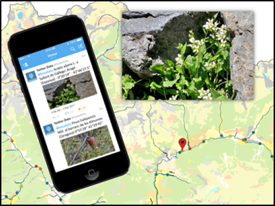
- The project FenoDato starts
-
On January began its activities the project FenoDato, awarded to Grumets in the recent Convocatoria de ayudas para el fomento de la cultura científica, tecnológica y de la innovación of the Fundación Española para la Ciencia y la Tecnología (FECYT). The project will last one year and will involve CREAF end the UAB Departament of Botany in a citizen science initiative, which aims to involve the non-specialized public in the collection of phenological observations through the Twitter platform. The observations will be added to a database, complemented with an interoperable interactive map to represent the data collected in real time. In addition, a mechanism for validating observations will be developed through an application for mobile devices consisting of a game where users have to identify species and phenological stages to first assess their criteria and then to check the quality of other observations. The idea comes from the synergy between the will of the Meteorological Service of Catalonia (SMC) to expand its network of observers and the interest of CREAF and the UAB to contribute to the development of geographic information technologies for the public. At the end of the action, the maintenance of the development will be transferred to the SMC and the code of the app will be released as open source.
-
-
6-02-2015
-
MiraMon celebrates 20 years
-
This 2014, MiraMon, the GIS and remote sensing software developed by the CREAF and the UAB, has celebrated the twentieth anniversary of its creation. Twenty years of life, of maps, of code, of courses, of cartography, of remote sensing imagery, etc. During these 20 years, thousands of users in dozens of countries have trusted and used the MiraMon in their professional and personal activities, generating ideas, products and results of great interest and importance in various fields. To celebrate it, the conference "Closer to the geoinformation 1994-2014" was organized on December 15th. You can read a chronicle of the event here (Spanish).
7-01-2015